Introduction[]

Global Positioning System (GPS) is a system that allows for the precise determination of the lattitude, longitude, and altitude of an object anywhere on the earth within inches of accuracy. It is also able to determine an objects velocity with great accuracy. It originally found its application in the military allowing for precision targeting, however it has extended to various more domestic applications such as navigation for automobiles, ships, and airplanes. In addition it has found its use in cellular phones, automobile theft recovery, and in child location devices. The use of the GPS itself is provided by the U.S. pentagon and is free of charge and available to everyone.

General[]
A GPS receiver works by measuring its distance from a group of satellites that orbit the earth. There are 24 satellites set apart for the global positioning system, over four of which are visible from any point on earth. A minimum of four satellites are necessary to pinpoint the position of a GPS receiver. The exact location and velocity of each satellite is monitored by the Department of Defense at every moment. A GPS receiver is thus able to measure its absolute position in space as an offest of multiple satellites' positions.
How it Works[]
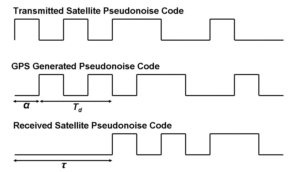
Pseudonoise Code
Let us consider four satellites, labeled Satellite 1, 2, 3, and 4. Each satellite generates two necessary signals: 1) a signal called a pseudonoise (PN) code, which is a deterministic waveform, and 2) the exact position of the individual satellite. The PN code is the signal used to modulate the baseband message generated by each satellite. Both of these signals are relayed by the satellites to a GPS receiver which is generating an identical PN code with a time offset of . The GPS receiver receives the position signal and PN code from Satellite 1, which take a finite amount of time ,, to reach it. The GPS receiver then compares the recevied PN code with time offset of to its self-generated PN code with time offset of . The time difference between the two signals, , plus thus represents the differential time it takes for Satellite 1's signal to reach the GPS receiver, . The rate at which a signal can be transmitted between a satellite and the earth is approximated by the average speed at which an electromagnetic signal travels through the air, . Thus the GPS recevier's distance from Satellite 1 is calculated as follows:


Radial Satellite Distances
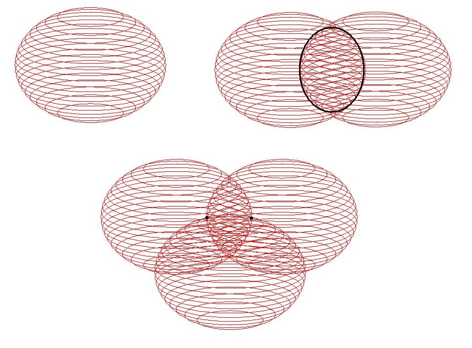
For the time being we assume that is equal to 0 even though it is not. The GPS receiver is able to locate its absolute position in space as a radial distance from Satellite 1. Thus it lies on a sphere with radius from Satellite 1, as shown in the figure to the right. The same process is used by the receiver to obtain its radius, , from Satellite 2. The intersection of the resultant sphere and the sphere corresponding to Satellite 1 results in a circle, somewhere on which the recevier lies. Similarly, the receiver's radial position from Satellite 3, , is obtained. Thus the receiver's absolute postion in space is narrowed down to just 2 coordinates, as shown to the right. To determine which of these two positions is valid is fairly simple as one of the positions will yield a ridiculous velocity or position of the receiver, such as a location not on earth.


We have defined the radial distances of the receiver from each satellite as a function of the speed of an EM wave, , which is a constant, and the time required for the wave to propagate to the receiver. was defined as the time offset between the satellites' sent PN code and the receiver's PN code plus the time . However has yet to be determined. Thus the necessity of Satellite 4 comes into play as it is used to determine the value of . Given that

can be determined as is the distance between the Satellite 4 and the receiver (which is known assuming = 0), is known, and is known (assuming = 0).

Example[]
Given:
The speed of an EM wave is

The time difference between the GPS receiver's PN code and Satellite 1's PN code,

The time difference between the GPS receiver's PN code and Satellite 2's PN code,

The time difference between the GPS receiver's PN code and Satellite 3's PN code,

The time difference between the GPS receiver's PN code and Satellite 4's PN code,

The distance between the GPS receiver and Satellite 4,

Find:
The radial distance of the GPS receiver from each of the 4 satellites.
Solution:
In general, radial distance=

So,


Alpha is consistent between the 4 equations because there is no time delay between the satellites' PN signal.
So,
,


Theory[]
Spread Spectrum System[]
Spread spectrum is a modulation scheme which GPS utlizes to encode its data. In spread spectrum, a baseband signal is modulated by a carrier code, which is called a psuedonoise (PN) sequence or code. Generally a PN code is a periodic binary signal. This code allows for secure communication as only desired parties can be allowed knowledge of the code. The modulated (spread spectrum) signal bandwidth is much greater than the message (baseband) signal bandwidth. The same line code is used at the transmitter and reciever to spread and unspread the signal.
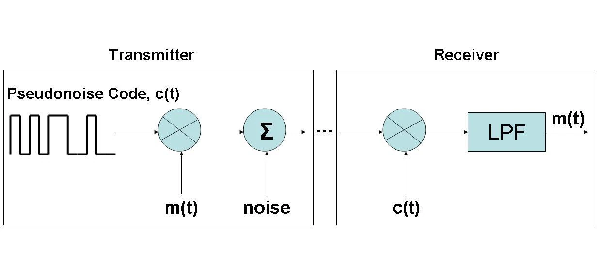

DS/SS Transmitter and Receiver
y(t)=m(t)*c(t)
m(t)=baseband signal
c(t)=pseudonoise (carrier) sequence
y(t)=DS/SS signal
This comes from the fact that c(t) is a polar signal thus


References[]
1. Lathi, B.P. (1998). Modern Digital and Analog Communication Systems (Third Edition), Oxford University Press, pp. 414